
Weather radar station upgraded
By Sean Feagan, Local Journalism Initiative Reporter
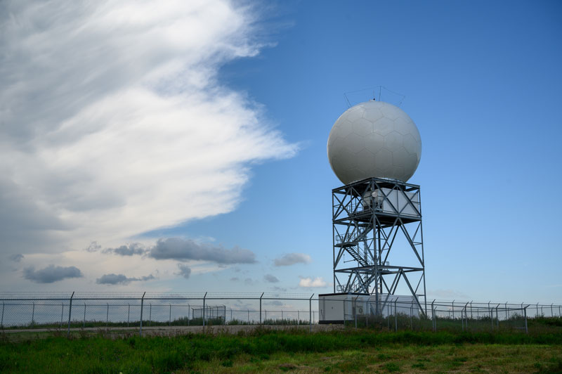
Sean Feagan Photo
Weather in Strathmore and Wheatland County can change in a flash – but the radar system located just north of town has been upgraded, giving area residents more time to react to storms.
The Canadian weather radar network is a group of 33 weather radar systems operated by Environment and Climate Change Canada (ECCC) distributed throughout the country to identify and track weather patterns. One of the stations is located just north of Strathmore, which provides weather detection services to much of southern Alberta and parts of B.C.
Each RADAR (radio detection and ranging) station works by first transmitting a brief pulse of energy into the atmosphere. Travelling at the speed of light, these waves travel outward from the station. If they hit something, such as water droplets, snow or hail, they “bounce” back towards the station, like an echo. Each station has receivers that “listen” for these echoes. Using the time between the initial pulse and its return, the distance to the “target” is calculated, which is used to build a picture of the form and movement of weather activity in each station area.
Efforts have been ongoing to upgrade these systems with new technologies that make weather prediction more accurate over greater areas, explained Gabrielle Lamontagne, ECCC spokesperson. The entire system is being upgraded, with an additional station being planned to be sited near Fort McMurray, Alta. The new system uses pulses from a different portion of the electromagnetic spectrum, which results in the network having improved detection capabilities.
The old system used C-band pulses, which are of a shorter wavelength, emitted at lower power, and released from a smaller antennae. One of the issues with this system is that they suffer from attenuation, meaning the signal decreases more rapidly as each pulse hits something in the atmosphere. This is a problem when there are multiple storm systems, because if there is a nearby storm, a farther-away storm will be less likely to be detected.
The new system uses an S-band that operates on a longer wavelength that is not easily attenuated. This means that it has a much better ability to pierce through storms, and hence, the detection of far-away systems is less likely to be blocked by activity closer to the station.
The new stations also provide better information because they use dual polarization technology, meaning they emit pulses both vertically and horizontally, compared to the older systems that only pulse horizontally. This change provides more detail on the size, shape and variety of a target system, allowing forecasters to better distinguish between rain, snow, hail and freezing rain. This information is important to industries such as commercial airlines, which have to make a decision on the safety of flying conditions based on the type of precipitation likely to be encountered. It also gives better identification of non-meteorological targets, such as birds or insects.
The move from C-band to S-band increases the systems doppler range from 120 kilometres (km) to 240 km per radar. This allows for extended tornado detection range, meaning residents will have more warning of extreme weather events, such as tornadoes. The extended range helps cover more of the nation, increasing the area that forecasters can monitor for severe weather. It also allows for more overlap between neighbouring radar systems, which makes the overall system more resilient in the case of outages.